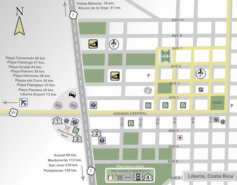
How is Liberia laid out?
Like most Costa Rican towns, Liberia is a grid. Avenidas run east to west and calles run north to south, all numbered out from Avenida Central and the central park. Most shops, banks, restaurants and places to stay are within a few blocks of the park, so the town center is easy to explore on foot.
Two highways meet on the west side of town:
- Highway 1, the Inter-American Highway, runs north to south along the town’s western edge. North, it passes the turnoff for Rincón de la Vieja National Park and continues to Peñas Blancas, the border crossing with Nicaragua. South, it heads toward Cañas and San José.
- Highway 21 heads west from the junction to Liberia airport and on to the beaches: Playas del Coco and the Papagayo side, then Flamingo, Conchal and Tamarindo.
How far is Liberia from the airport and the beaches?
The distances printed on the map are road distances from town. From Liberia airport (LIR), here’s how long the drive takes:
- Liberia town: 12 km, 15 to 20 minutes
- Playas del Coco, Playa Hermosa and Ocotal: about 30 minutes
- Flamingo and Conchal: 1 hour to 1 hour 30
- Tamarindo: 1 hour 15 to 1 hour 30
- Rincón de la Vieja (Las Pailas): 45 minutes to 1 hour 15
See Guanacaste drive times for every beach, volcano and hot spring, including the drives between them.
Staying the night in Liberia?
Landing late or flying out early? A night in town or by the airport makes the next day much easier. See hotels near Liberia airport, and plan your transportation here: your driver meets you at arrivals with a sign bearing your name.